Among the great peaceful endeavors of mankind that have contributed significantlyto progress in the world, the construction of the Canal stands as an awe-inspiring achievement.
The unparalled engineering triumph was made possible by an international work force under the leadership of American visionaries, that made the centuries-old dream of uniting the two great oceans a reality.
In 1534, Charles I of Spain ordered the first survey of a proposed canal route through the Isthmus of Panama. More than three centuries passed before the first construction was started. The French labored 20 years, beginning in 1880, but disease and financial problems defeated them.
In 1903, Panama and the United States signed a treaty by which the United States undertook to construct an interoceanic ship canal across the Isthmus of Panama. The following year, the United States purchased from the French Canal Company its rights and properties for $40 million and began construction. The monumental project was completed in ten years at a cost of about $387 million. Since 1903 the United States has invested about $3 billion in the Canal enterprise, approximately two-thirds of which has been recovered.
The building of the Panama Canal involved three main problems-engineering, sanitation and organization. Its successful completion was due principally to the engineering and administrative skills of such men as John F. Stevens and Col. George W. Goethals, and to the solution of extensive health problems by Col. William C. Gorgas.
The engineering problems involved digging through the Continental Divide; constructing the largest earth dam ever built up to that time; designing and building the most massive canal locks ever envisioned; constructing the largest gates ever swung; and solving environmental problems of enormous proportions.
Now more than 75 years after the first official ocean-to-ocean transit of the waterway, the United States and Panama have embarked on a partnership for the management, operation and defense of the Panama Canal.
The Vital Link for World Trade
The Panama Canal, with its uinque location at the narrowest point between the Atlantic and Pacific oceans, has had a rar-reaching effect on world economic and comercial developments throughout most of the 20the century. By providing a shorter, relatively inexpensive passageway between these two great bodies of water, the Canal has influenced world trade patterns, spurred growth in developed countries, and has been a primary impetus for economic expansion in many remote areas of the world. For example, a vessel laden with coal saling from the east coast of the United States to Japan via the Panama Canal saves about 3,000 miles versus the shortest alternative all-water route, and for a vessel laden with bananas sailing from Ecuador to Europe the distance saved is about 5,000 miles.
By far, most of the traffic through the Canal moves between the east coast of the United States and the Far East, while movements between Europe and the west coast of the United States and Canada comprise the second major trade route at the waterway. Other regions and countries, however such as the neighboring countries of Central and South America, are proportionately more dependent on this vital artery to promote their economic development and expand trade.
Since the Canal first opened on August 15, 1914, the waterway has provided a quality transit service to more than700,000 vessels. Despite the increase in the number and size of transiting vessels in recent years, the total time spent by a vessel at the Panama Canal still remains at slightly less than 24 hours. This remarkable level of performance can be attributed to the team of professionals trained to provide rapid transit service and to the rimely implementaion of improvements designed to interface with traffic demand. Some $10 million dollars is spent each year on training rograms to prepare Panamanians for the operation and maintenance of the Canal. Today, Panamanians comprise more than 8 persent of the Canal's seasoned work force, and occupy positionss in high-skilled areas vital to the Canal organization.
Of the thousands of vessels transiting the Canal each year, about 23 percent of the total ocean-going transits are by PANAMAX-size vessels, the largest vessels the waterway can accommodate. An optional transit reservation system is available upon request to provide a guaranteed priority transit, The natue of improvements to the Canal keenly reeflect the ever increasing role of PANAMAMAX vessels in the movement of world commerce. Use of the all-water routes through the Panama Canal, will continue to be an important, cost-effective transportaion mode for a significant segment of world trade.
Maintenance
As with any operation of the magnitude and complexity of the Panama Canal, round-the-clock maintenance is critical to its effectiveness and efficiency. Approximately $450 million is spent each year for the overall operation of the Panama Canal, of which nearly $100 million is committed to maintaining and improving the waterway. Regular dredging of the main channel virtually assures a year-round maximum draft of 39.5 feet even during dry periods. Because the Panama Canal Commission recognizes and emphasizes the requirement for good maintenance, regular overhauls of miter gates, chambers, culverts and valves are scheduled to keep the Locks in top operating conditon.
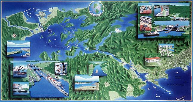
The Physical Features of the Panama Canal
The Panama Canal is 50 miles long from deep water in the Atlantic to deep water in the Pacific. It was cut through one of the narrowest and lowest saddles from the long, mountainous Isthmus that joins the North and South Amercan continents. The orignal elevation was 312 feet above sea level where it crosses the Continental Divide in the rugged mountian range.
The canal runs from northwest to southeast with the Atlantic entrance being 33.5 miles north and 27 miles west of the Pacific entrance. Air distance between the two entrances is 43 miles.
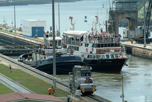
It requires about 9 hours for an average ship to transit the canal. During this brief time, the passengers aboard have an opportunity to see one of the modern wonder of the world in operation, its principal physical features are the two terminal ports, short sections of the channel at either end at the sea level, and the three sets of twin locks, Gatun Lake, and Gaillard Cut.
A ship that transits the Canal from the Atlantic to the Pacific enters the channel form Limon Bay at the Cristobal breakwater.
This sea-level section of the Canal channel on the Atlantic side is 6 and a half miles long and 500 feet wide and runs through a mangrove swamp that is only a few feet above sea level in most places.
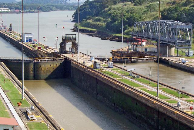
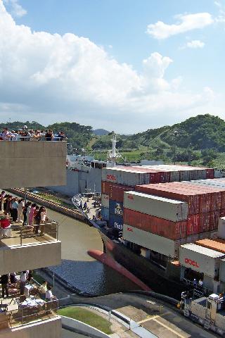
A ship is raised or lowered 85 feet in a continuous flight of three steps at Gatun Locks. Each lock chamber is 110 feet wide and 1,000 feet long. The length of Gatun Locks, including approach walls, is one and a half miles.
Gatun Lake and Dam
Gatun Lake, through which the ships travel for 23 and a half miles from Gatun Locks to the north end of Gaillard Cut, covers an area of 163.38 square miles and was formed bya earthen dam across the Chagres River adjacent to Gatun Locks. The two wings of the dam and the spillway have an aggregate length of about one and a half miles. The dam is nearly a half mile wide at the base, sloping to a width of 100 feet at the crest, which is 105 feet above sea level, or 20 feet above the normal level fo Gatun Lake.
GailIard Cut
Because of its history, its unusual geology and the fact that it slices through the Continental Divide, Gaillard Cut holds special interest for ship passengers transiting the Canal. During the Canal construction period it was called Culebra Cut, but was renamed for Col. David DuBose Gaillard, the engineer who was in charge of this section of the Canal work.
This portion of the channel is about eight miles long and was carved through rock and shale for most of the distance. It was here that the principal excavation was required and here that the devastating slides occurred during construction and soon afer trhe Canal was opened.The ships enter the Cut where the Chagres River flows into the Canal channel at Gamboa. More than any other section of the Canal, Gaillard Cut gives the impression of the waterway as an enormous ditch. A short distance before the ship reaches Pedro Miguel Locks it passes Gold Hill on the left, the highest promontory along the channel. It rises 587 feet above sea level.
Contractor's Hill, seen on the west bank opposite Gold Hill, originally had an altitude of 410 feet, this was reduced to 370 feet to stabalize the hill in 1954. The channel in Gaillard Cut was originallyexcavated to a width of 300 feet. During the 1930's and 1940's, the straight section imediately north of Gold Hill was widened to 500 feet to provide a passing secton for large ships, and during the period 1957 - 1971, the remaining portions of the Cut were also widened to 500 feet.
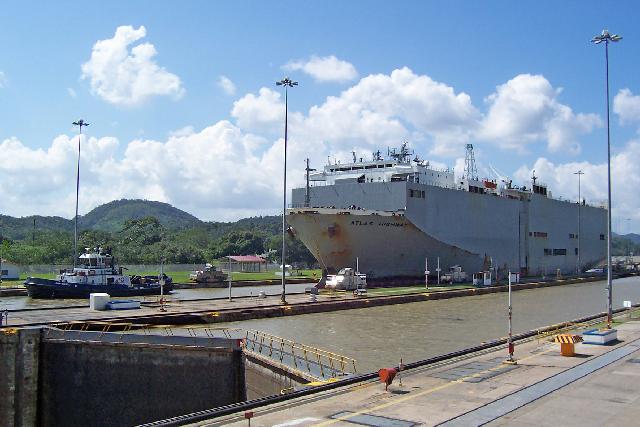
The Pacific-bound ship enters Pedro Miguel Locks at the south end of Gaillard Cut. Here is is lowered 31 feet in one step to Miraflores Lake, a small artifial body of water a mile wide that separates the two sets of Pacific locks. The length of Pedro Miguel Locks if 5/6 of a mile.
The transiting ship is lowered the remaining two steps to sea level at Miraflores Locks, which are slightly over a mile in length. The lock gates at Miraflores are the talest of any in the system because fo the extreme tidal variation in the Pacific Ocean.
The Panama Canal is the 8th Man made wonder of the world and the focus of many of our travelers on our tour packages. The route taken on full Panama Canal transits, which are offered usually only once per week. Full transits begin at the southeastern (or Pacific) entrance of the Panama Canal in Balboa and travels the entire length of the canal and ends in Christobal on the northwestern (Atlantic Coast) where we off-load from the transit vessel and transfer back to Panama City by bus. Partial Panama Canal transits are offered each week north and bound from Flamenco Island to Gamboa.
The Panama Canal
Since
1992
 | ||||||

Professional
Bilingual Guides
Copyright 2013: Panamacanal.com | Panama Canal Travel | All rights reserved.